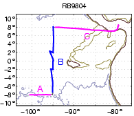
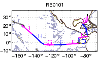
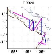
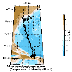
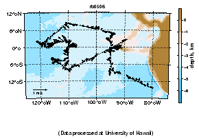
GP6-98-RB
November 1998
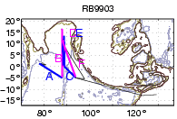
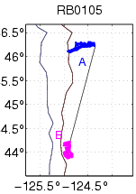
Primary line along 95oW. across Equator.
examine data
or download postscript of map
(back to top)
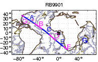
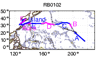
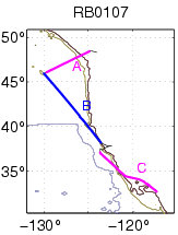
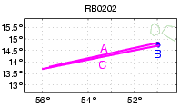
Aerosols
Jan 9 - Feb 20, 1999
Trans-Atlantic: Norfolk,VA to Capetown; Indian Ocean to Mauritius
examine data
or download
postscript of map
(back to top)
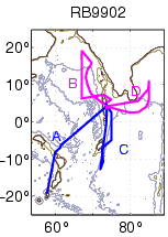
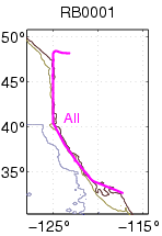
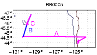
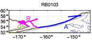
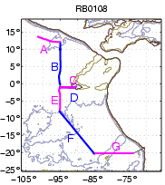
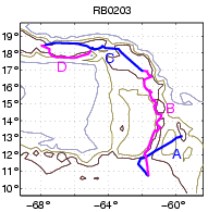
Maldives-99
Feb 22 - Apr 4, 1999
Transit from Port Louis, Mauritius to Maldives (4oN and 74oE), and three circuits among Maldives
(See below for contour plots)
examine vector data
or download
postscript of map
(back to top)
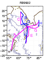
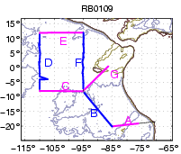
Maldives-99
Feb 22 - Apr 4, 1999
Transit from Port Louis, Mauritius to Maldives (4oN and 74oE), and three circuits among Maldives
(See above for vector plots)
examine contour data
or download
postscript of map
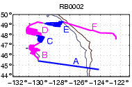
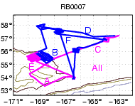
Jasmine-99
Apr 7 - June 8, 1999
Maldives to Singapore to Darwin, Australia ,
with several intense circuits near (12oN and 88oE)
examine data
or download
postscript of map (back to top)
Link to the comprehensive " JASMINE " (Joint Air-Sea Monsoon INteraction Experiment) data.
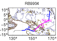
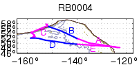
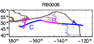
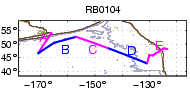
Nauru-99
June 15 - July 7, 1999
Transit from Darwin, Australia to Nauru (0.5oS and 167oE),
and several circuits around Nauru
examine data
or download
postscript of map
(back to top)
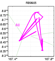
TRMM-99
July 18 - Aug 12, 1999
Stationed at Kwajalein Atolls (8.4oN and 167.6oE)
examine data
or download
postscript of map
(back to top)
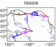
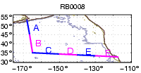
Moorings-99
Sept 13 - Nov 1, 1999
Kwajalein Atolls to Dutch Harbor AK to Seattle WA
examine data
or download
postscript of map
(back to top)
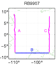
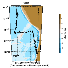
GP8-99-KA
Nov 11 - Nov 29, 1999
Primary lines along 110o and 95oW.
examine data
or download
postscript of map
(back to top)
Transit only
Feb 24 - Feb 28, 2000
San Diego CA to Seattle WA
examine data
or download
postscript of map
(back to top)
VENTS
March 9 - April 4, 2000
Newport OR to Seattle WA
examine data
or download
postscript of map
(back to top)

FOCI
April 13 - April 30, 2000
Seattle WA - Seattle WA
examine data
or download
postscript of map
(back to top)
Haruphone/Tsunami
May 20 - June 4, 2000
Seattle WA - Kodiak AK - Seattle WA
examine data
or download
postscript of map
(back to top)
VENTS
June 17 - Aug 4, 2000
(Victoria BC) - Newport OR - (Seattle WA)
examine data
or download
postscript of map
(back to top)
NOPP/DART
Aug 10 - Aug 22, 2000
Seattle WA - Dutch Harbor AK
examine data
or download
postscript of map
(back to top)
FOCI
Aug 27 - Sept 23, 2000
Dutch Harbor AK - Dutch Harbor AK
examine data
or download
postscript of map
(back to top)
NOPP/MAMA
Sept 27 - Nov 9, 2000
Dutch Harbor AK - San Diego CA
examine data
or download
postscript of map
(back to top)
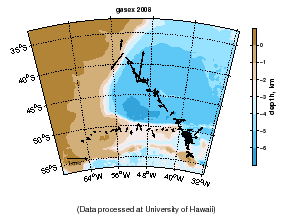
GASEX
January 24 - March 8, 2001
Charleston SC - Panama - Hawaii
examine data or
download postscript of map
(back to top)
ACE Asia
March 4 - April 19, 2001
Hawaii - Yokosuka, Japan
examine data or
download postscript of map
(back to top)
FOCI
May 26 - June 8, 2001
Kodiak AK - Dutch Harbor AK
examine data
or download
postscript of map
(back to top)
Tsunami/Haruphones
June 8 - June 22, 2001
Dutch Harbor AK - Victoria BC
examine data
or download
postscript of map
(back to top)
Ocean Exploration/Groundfish
June 28 - July 12, 2001
Oregon coast
examine data
or download
postscript of map
(back to top)

VENTS/ROPOS
July 14 - Aug 1, 2001
Oregon to Victoria BC
examine data
or download
postscript of map
(back to top)
VENTS Pioneer Seamount
Aug 28 - Sept 3, 2001
Seattle WA to San Diego CA
examine data
or download
postscript of map
(back to top)
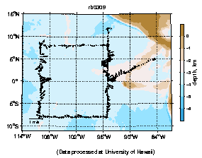
EPIC
Sept 10 - Oct 25, 2001
San Diego to Galapagos to Arica, Chile
examine data
or download postscript of map
(back to top)
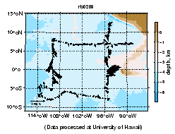
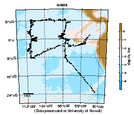
TAO
Oct 30 - Dec 2, 2001
Arica, Chile to Panama
examine data
or download
postscript of map
(back to top)
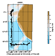
AOML
Feb 1 - Feb 24, 2002
Recife, Brazil to Bridgetown, Barbados
examine data
or download postscript of map
(back to top)
NTAS-2
Feb 1 - Feb 24, 2002
Bridgetown, Barbados and return
examine data
or download postscript of map
(back to top)
Mar 9 - Mar 18, 2002
Bridgetown, Barbados to St. Thomas USVI
examine data or
download postscript of map
(back to top)
Aug 27 - Sept 15
Sept 19 - Sept 30
Oct 11 - Nov 6
TAO
Oct 27 to Nov 21, 2003
OS75 instrument installed
Stratus Mooring
October 10 - October 20, 2005
TAO
2005/10/27 to 2005/11/25
2006/10/13 to 2006/10/27
2006/11/03 to 2006/12/02
2007/10/16 to 2007/11/06
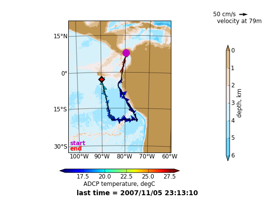
Stratus mooring - Charleston,sc to rodman,panama to galapagos islands
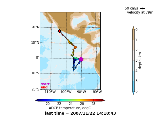
2007/11/11 to 2007/11/22
Stratus mooring - Galapagos Islands to San Diego, CA
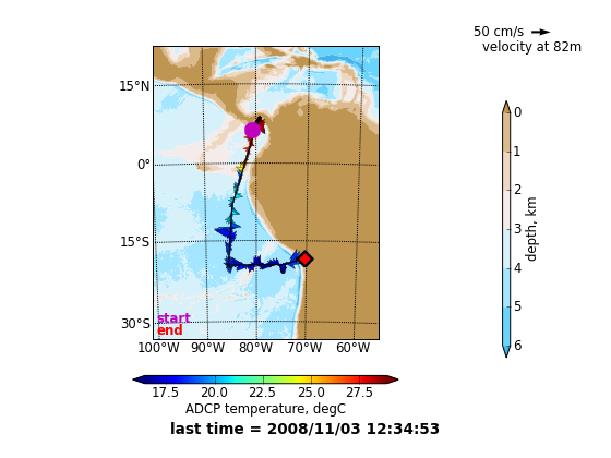
2008/03/01 to 2008/04/11
Punta Arenas, Chile - Montevideo, Brazil
os75nb sections:
examine data or download postscript of map
os75bb sections:
examine data or download postscript of map
(back to top)
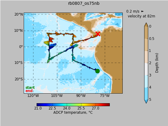
2008/10/15 to 2008/11/03
Rodman, Panama - Arica, Chile

22008/11/10 to 2008/12/01
Arica, Chile - Arica, Chile
2008/12/12 to 2009/01/11